By Arthur LaCour - Handheld Tours
(in Volume 27)
Handheld Tours is a self-guided tour development company specialising in interactive interpretive visitor experiences. Our solution is app based and operates on smart devices (tablets, phones, Apple watch). It is available on both the Android and Apple systems which together provide more than 95% of market coverage. Our solution is feature rich, but our goal is to make it easy to use and not intrusive, visitors use their own smart devices greatly reducing the technology learning curve.
“Beyond the next decade, leisure trips in England will be increasingly affected by consumers’ use of technology, especially as access to and use of mobile devices becomes ever more widespread and sophisticated. For many consumers, the use of such devices will become an integral and immersive part of every aspect of their trip” Visit England – Domestic Leisure Tourism for the next decade. 2013
Visit England’s document also stated that Mobile First’ is a particularly crucial trend for tourism businesses. Consumers’ desire for immediate information will change not only the method by which they plan and book holidays but the overall process of doing so. Consumers will also expect to be able to easily curate their leisure time to fit in with other demands on their time (such as work and family) Developments in both consumers’ access to and use of technology will have a transformative effect on the future of domestic leisure tourism. Experts agreed that technology development and consumer access to information would be hugely impactful for the future of domestic tourism. Wider technology use is changing how people research and book their holidays – and what they expect whilst there.
This shift in how people use technology in their leisure time has many benefits. There are nearly limitless content delivery capabilities, enhancing user experience. This may encourage visitors to stay longer and visit more of the area with curation. It offers improved access to points of interest (intellectual & physical), with content about the location and GPS navigation to help find it. It is available 24 X 7 to fit visitor’s schedules and how they want to plan their trip. It is a Green solution – no printing or physical distribution costs and no long waits, costly redesigns or print runs to reflect changes or upcoming events. It also meets visitors digital and “on-demand” rich interactive experience expectations. There is also the fact that integrated data analytics help land and facilities managers to understand how often they are used and when demand is occurring. The systems can be used to promote local businesses and attractions as visitor services and can also deliver heritage and cultural messages promoting awareness, volunteering and encourage users to care about and for the town. Finally it may help attract new visitor groups who might not otherwise be attracted or engage with printed content or even discover it.
Chilterns AONB Case Study
The challenge the Chilterns AONB identified was to engage or re-engage people with the countryside and the various visitor and other attractions in the area. The Chilterns AONB has an excellent walks portfolio though it’s increasingly seen as a “legacy” asset given the portfolios A4 PDF/paper based formats inability to keep pace with technological change and user demands. Navigation was a key issue, the highly stylised maps didn’t translate well to the on the ground experience, making route following difficult, particularly for novices, putting off potential users. Route attractions were also difficult to accurately locate and promote due to A4 paper/PDF format constraints which also heavily restricted content further compromising the user experience. This was all combined with high print costs driving the large production runs necessary to achieve an economies of scale. Ultimately this drove an inflexible update programme resulting in the assets datedness. The current formats now limited ability to drive customers combined with a lack of data metrics also limited its attractiveness to potential sponsors and advertisers.
Nature provides an engaging and fascinating show, but many lack sufficient navigation skills to allow easy access much less knowledge of how to interpret its’ amazing story.
To meet the twin challenges of high visitor content expectations and limited navigation experience the project decided to leverage familiar technology – the smart device. So a series of self-guided walks were made available for download to mobile phones, tablets and the Apple watch. These walks once downloaded did not need a data connection – only GPS for them to then work. By doing this it was hoped to create user confidence and engagement with both the built and natural landscape. The ultimate goal was to be able to provide a user with their own personal guide, while driving down delivery costs and increasing content flexibility.
There were of course challenges to be faced, here are a learning points from the project:
- If behaviour needs to change, change yours, not the users.
- Envision the experience end to end, it starts earlier than you think and covers everything from tech to content.
- Directional information is obsolete in this environment, stripping it from traditional paper/PDF based formats can often leave you requiring content
- Most of the effort relates to content creation/modification not technology issues
- Consider data analytics, everyone wants to know the stats.
- Simplification is key to getting people use such a solution – they are unwilling to invest time in learning complicated technology and that trend is set to continue.
- It’s important to keep in mind that digital enables the experience, it’s not the experience.
How it works in action.
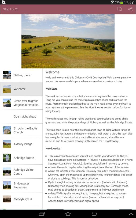
- Simply download the Handheld Tours app and choose a walk
- Once a walk is downloaded a Wi-Fi or data connection is no longer required for navigation (only a GPS signal) or content access
- The fully zoom able map supports 3 navigation modes, displays the users current location, the full route and active POI (point of interest) hotspot markers
- POI markers open with a tap, displaying available geo-located content (photos, text, audio, video, hyper-links) integrated on a page for easy use
Hand Held Tours can provide a wide range of services to support the development of this type of guided route map. These include
- project management and requirements guidance
- a comprehensive range of walk/tour creation services including: research, writing, sub-editing, photography, route design etc. or we can just transition existing content.
Solution highlights
- Shared and white label app options available
- Instrumented using Google Analytics for the Android and iOS OS’s for anonymised data collection
- Platform enhancements to take advantage of developing technology trends and bug fixes to ensure compatibility with the latest Android & iOS OS releases are included
- Geo-fencing support to alert users as they approach POI
- Minimal storage footprint with individual walk deletion and move to SD card features
- Support for 14 languages
- Utilises low-drain battery technology
- Supports multiple map types
- Seamlessly integrates, photography, text, audio, video, hyper-linked content
- Social media integration
- Solution supports any mode of transport (bus, car, bike, boat, horseback)


